About Mobile Topographer GIS
The beloved choice of the professionals, Mobile Topographer ...meets... GIS . You can now perform a complete survey without any limitations into complexity or volume of data. Try now Mobile Topographer GIS by u
The beloved choice of the professionals,
Mobile Topographer ...meets...
GIS .
You can now perform a complete survey without any limitations into complexity or volume of data.
Try now Mobile Topographer GIS by using the three days free trial period. Just download the app and proceed with he subscription procedure. Although, you will be asked to provide billing information, you will NOT be charged before the end of the three days of the free trial period. You can cancel your subscription at any time during the three days trial period, free of charge. Charges will only occur, if at the end of the three days you still have an active subscription.
- Collect GNSS readings using increased accuracy (GPS, GLONASS, Galileo, Beidou, QZSS constellations supported).
- Connect your external GNSS receiver via mock locations and use Mobile Topogrpaher GIS as a processing unit.
- Display data into WGS84 or you local projected CRS.
- Convert from WGS84 to local projected CRS and vice versa.
- Real time projection on map.
- *** NEW *** Custom image or WMS server as map background.
- Find a marked point in the real world by using "Drive me"
- Calculate Orthometric height on the fly using EGM model or local elevation grids where available.
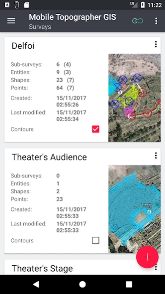
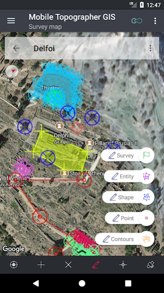
- Organize your work into Points - Shapes - Entities & Surveys. You can now create individual points, multi-point groups, multipart polylines, and multipart polygons with holes.
- Create a full drawing with as much details as you want.
- *** NEW *** geodetic tools. Add indirect points via on of the following options: 1 point + Distance + Azimuth, 2 points + Distances + Select, 2 points + Azimuths, 3 points + Distances, Midpoint of line, Divide line, Extend line, Parallel line, Perpendicular to line.
- Nest your jobs, in any nesting level, to create a super-survey.
- Share data between jobs with active links.
- Exchange jobs between your mobile device and your desktop computer, with import - export functions using all common formats .txt, .csv, .kml, .gpx, .dxf and Shape files (.shp - .shx - .dbf)
- Collaborate with your partners by exchanging and sharing from one point to complete jobs.
- Create the 3D terrain of an area by simply walking through it.
- Calculate contours and add them into your survey with lightning speeds.
- View a real 3D model directly into your device.
- Store a route with its data.
- Show GNSS satellites with signal info in both compass view or AR.
- Backup and restore your data using an SQL .db file.
Welcome to the era of mobile surveying...!
Find more about Mobile Topographer GIS in:
http://applicality.com/projects/mobile-topographer-gis/
Download the user's manual from:
http://applicality.com/app_documentation/web/MobileTopographerGIS_Manual.pdf
Previous Versions
Here you can find the changelog of Mobile Topographer GIS since it was posted on our website on 2019-08-23 14:03:19.
The latest version is 6.0.15 and it was updated on 2024-04-22 12:33:26. See below the changes in each version.
Mobile Topographer GIS version 6.0.15
Updated At: 2023-06-21
Changes: v.6.0.15 - More bug fixes.
Mobile Topographer GIS version 6.0.14
Updated At: 2023-05-14
Changes: v.6.0.14 - Minor bug fixes.
Mobile Topographer GIS version 6.0.11
Updated At: 2023-04-18
Changes: v.6.0.11 - Bug fixes.
Mobile Topographer GIS version 6.0.9
Updated At: 2023-03-26
Changes: v.6.0.9
Mobile Topographer GIS version 6.0.8
Updated At: 2022-03-06
Changes: v.6.0.8 - Minor bug fixes.
Mobile Topographer GIS version 6.0.6
Updated At: 2022-02-13
Changes: v.6.0.6 - Minor bug fix.
Mobile Topographer GIS version 6.0.4
Updated At: 2022-02-07
Changes: v.6.0.4 - Bug fixes.
Mobile Topographer GIS version 6.0.3
Updated At: 2022-02-06
Changes: v.6.0.3 - Bug fixes.
Mobile Topographer GIS version 6.0.2
Updated At: 2022-01-18
Changes: v.6.0.2 - Fixing compatibility issues with android 11. New file access framework implemented.
Mobile Topographer GIS version 5.0.8
Updated At: 2021-10-05
Changes: v.5.0.8 - Minor bug fix.
Disclaimer
Official Google Play Link
We do not host Mobile Topographer GIS on our servers. We did not scan it for viruses, adware, spyware or other type of malware. This app is hosted by Google and passed their terms and conditions to be listed there. We recommend caution when installing it.
The Google Play link for Mobile Topographer GIS is provided to you by apps112.com without any warranties, representations or guarantees of any kind, so access it at your own risk.
If you have questions regarding this particular app contact the publisher directly. For questions about the functionalities of apps112.com contact us.